
March 26, 2011. 2:46 PM local time. Location is 62 miles off the northern shore of the Island of Honshu, Japan, and nineteen miles beneath the earth’s surface. The tension between the massive Pacific Plate and the colossal North American plate (this is not a typo – see the Tectonic Plate Map here) is at its breaking point. The Pacific Plate, with its slow, arduous friction filled movements, is sliding at its slow, three inch per year struggle, under the North American plate, has been building up tension against its inhibiting neighbor for centuries. The bulge in North American plate has been developing over time from the growing intensity of this pent up energy. With little warning, the Pacific Plate can no longer hold its grasp on the North American plate, releases its fading grip in an epic dispersion of energy, the likes of which, Japan has never seen before in recorded history. As the upper North American plate releases its energy, it caused massive vibrations through the ground, called Rayleigh Waves, felt hundreds of miles away.
The earth released its first inkling of this surprise tremor at fourteen minutes to three, local time. The region had experienced three tremors earlier in the week, all of which were short lived, but big enough to make you say, ‘hey, an earthquake!’, and forgotten about with little afterthought. But this one, kept going.
Two hundred miles away, in Kashiwa, Japan, Chris Goldfinger, renowned Paleoseismologist at Oregon State University was at a convention for – what else – seismologists. The group felt the initial movement and all laughed at the irony of it. An earthquake hitting while a bunch of geologists and seismologists are at a meeting to talk about earthquakes. When the tremor first started sending its waves through the ground, the group was not too worried about it. Goldfinger looked at his watch shortly after it started – a habit most seismologists and geologist who study earthquakes have. The duration of the shaking is a fairly accurate, albeit, crude, indicator of the magnitude of an earthquake. As the shaking moved past one minute and into two minutes, the group moved outside into the cold and snow. At three and four minutes, the group, as a whole, realized, somewhat in unison, the enormity of what they were experiencing. Some started filming the event on their phones, while others pulled out theirs to watch live streaming video from the front lines, on the eastern shores of the Tohoku region of Japan. At four minutes, they knew that they were in territory the vast majority of seismologists didn’t ever think Japan’s numerous faults could produce: A magnitude 9.0 earthquake. For six, long, agonizing minutes, the ground shook.
Earthquakes of this magnitude are created by only one type of fault; a subduction zone. One crustal plate sliding beneath another. In this century, there have been quite a few subduction zone quakes, noting a few, Chile’s record magnitude 9.5 in 1960; 1964’s Anchorage, Alaska magnitude 9.2quake; the 2004 magnitude 9.1 Sumatra quake; and the 2011 Tohoku Japan quake. What makes the subduction zone quake, or a megathurst earthquake, so powerful?
It’s a loose correlation, but one that gives you the same basic example of what is happening in a megathrust earthquake. Press your forefinger to your thumb, like you’re making the ‘okay’ sign. Put pressure on the two fingers. Now flick your forefinger forward like you’re flicking a fly off the table. That flicking action is similar to the releasing action of a subduction zone quake, albeit on a microscopic scale, comparatively speaking. Think of the bulge in the Pacific Plate as if it’s your forefinger bent over and onto the palm side of your thumb – representing the North American Plate (or Continental Plate). As the forward most point of the upper plate begins to bend, much like your forefinger, it creates pressure. Similarly, as you put more and more pressure on the union of the two fingers, the potential energy increases until your forefinger breaks the grasp of the thumb and flicks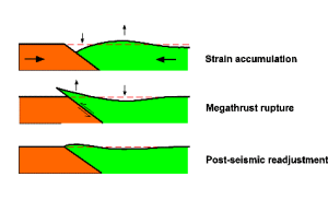 forward in an up and forward thrusting motion. Now, imagine that same general idea, but a much grander scale – couple of hundred miles long, and many miles under the ocean’s surface. This flicking action on the grand scale of the earth, is a megathrust earthquake.
To give you an idea of the power it produced, the 2004 Sumatra quake released as much energy as 475,000 kilotons of TNT, or equivalent to 23,000 Nagasaki atomic bombs. Mount St. Helens in Washington State erupted on May 18th, 1980. Its energy release was equivalent to 24 megatons of thermal energy (1800 Hiroshima atomic bombs). The Tohoku magnitude 9.1 quake was 199.526 bigger and 2818 times stronger than the 1989 6.8 magnitude Loma Prieta quake.
The flicking action is only part of the big picture. The Japan Trench, the origin of the Tohoku quake, experienced what is called a ‘full rip’ megathrust quake, where the entire length of the fault releases it’s energy in a similar flicking motion. As the pressures on the fault continued to release along its length, the two plates ground and slid passed each other – in some areas by as much as 260′, raising the ocean floor by as much as 130′ over an area the size of Connecticut. The earthquake released so much energy that it moved the island of Honshu eastward by eight feet, lowered the coastline by just over three feet, and shifted the earth on its axis by 10 centimeters.
When the energy build up at the union of the two plates was released, it displaced the ocean water, forcing it up by as much as 39 meters in some areas – roughly 130′. That upward thrust itself, called the vertical displacement, is what causes the terrifying and massively destructive secondary part of underwater full thrust earthquakes: the tsunami.
As the shaking subsided, six minutes after it started, the tsunami was already well on its way to the eastern shores of Honshu Island. Fifteen minutes after the initial shaking, the massive tsunami washed ashore, decimating low lying coastal plains for as far as six miles inland. Japan had long prepared for earthquakes of epic proportions, but research to this point, indicated that none of the faults in or around the islands would be able to produce a quake greater than 8.4. Sea walls, constructed based on this theory, were woefully inadequate. The raw overwhelming power of the tsunami proved them to be no match for its momentum and power.
Confusion reigned as citizens, not sure if there would be a tsunami, and if so, how big, waited expectantly for it to arrive, believing it would be stopped by the well designed and constructed sea walls. As the powerful tsunami moved past the sea walls and into coastal settlements, only those fortunate enough (or wise enough to leave immediately) to be able to get to high enough ground soon enough survived the terrifying power of the wall of water and debris. Ships anchored at harbor were deposited on top of four story buildings like Matchbox cars on a Lego town. Whole villages were literally obliterated. Many low lying geographical points were redesigned by the might and will of the debris laden water. Worst of all, the Fukushima Nuclear Energy plant was ill prepared for an earthquake and tsunami of such scale, resulting in meltdowns of the facility’s nuclear reactor, and release of radioactive material.
We are now just over four years past the devastation of the Tohoku Earthquake. Much has been learned from this cataclysmic event. There is still much to learn. Scientists, geologists and all sorts of people with degrees ending in ists will be studying this earthquake for years to come. Hopefully, those of us on the US West Coast will learn from this event. If Japan was caught off-guard, and they were highly prepared, how much more do we need to do to be prepared?